|
|
Description: |
|
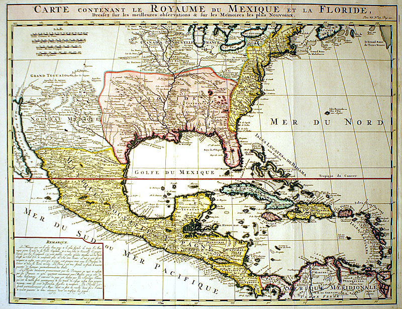
| M-12644: (Image: 16 x 20 1/2'') ''CARTE CONTENANT LE ROYAUME DU MEXIQUE ET LA FLORIDE...'' Guillaume De l'Isle. Amsterdam: Henri Abraham Chatelain, c. 1719. Engraved map with later hand-color. (Ref: Phillips, A List of Maps of America in the Library of Congress, p. 567).
This handsome important map is the first Chatelain issue of the famous De l'Isle map depicting the latest information from explorers. It accurately portrays the course and mouth of the Mississippi, the Great Lakes Region and settlements along the East and Gulf Coasts. English Colonies, Indian Villages, Spanish Missions and Hopi Mesas are located. The vast region, later known as Louisiana, from Florida through present-day Texas is shown as the French possession of Floride. The REMARQUE provides additional information concerning the fertile lands of Florida and New Spain. The West Indies and Central America are also well detailed with most islands identified. An attractive view of the region as it was known in the early 18th century! |
| Inventory Number: |
M-12644 |
|
|
Dealer |
Charles Edwin Puckett |
| Contact |
Charles or Teresa Puckett |
Phone: 330-668-0032 |
|
| Period: |
18th Century (1701-1800) |
|
| Date: |
c. 1719 |
|
| Origin: |
Published in Amsterdam |
|
| Condition: |
Excellent |
|
| Measurements: |
Image: 16 x 20 1/2'' |
|
| Inventory |
Other Inventory by this Dealer |
|
| Web-site: |
http://www.cepuckett.com |
|
| Price: |
SOLD |
|
| E-mail: |
Inquire
|
|
Click thumbnail
to view larger
|
)
)
)
)