|
|
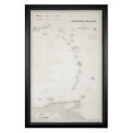
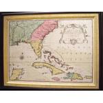
Chart of the Caribbean Islands by James Imray & Son, 1866; Chart of the Caribbean Islands published by James Imray & Son, London, 1866
Offered by: Find Weatherly, LLC
View more details |
|
|
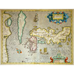
M-11579 - JAPAN & KOREA - Hondius, c. 1606; ''IAPONIAâ¦'' Amsterdam: Jodocus Hondius, c. 1606. Verso: French. Beautifully engraved map with skilfull old hand-coloring...
Offered by: Charles Edwin Puckett
View more details |
|
|
M-13974 - Early Map depicting Virginia to Florida - Hondius, c. 1613; M-13974: (Image: 13 3/8 x 19ââ â 340 x 485mm) âVIRGINIAE Item et FLORIDAE...â Gerard Mercator. Amsterdam: Jodocus..
Offered by: Charles Edwin Puckett
View more details |
|
|
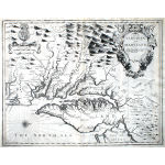
M-13973 - Map of Virginia & Maryland, Speed, c. 1676; M-13973: (Image: 14 ¾ x 19 ¼ââ) âA Map of VIRGINIA AND MARYLANDâ¦â London: John Speed, 1676. Exceptionally fine en..
Offered by: Charles Edwin Puckett
View more details |
|
|
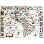
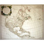
M-13904 - Cornerstone map of the Americas, c. 1644 Blaeu - Cartes a Figures ; M-13904: (Image: 16 ¼ x 22ââ) âAMERICAE nova Tabula.â Amsterdam: Willem J. Blaeu, c. 1644. Very fine engraved map..
Offered by: Charles Edwin Puckett
View more details |
|
|
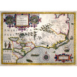
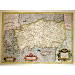
M-13196 - Map of Turkey and Greece, c 1623 - Mercator-Hondius; M-13196: (Image: 13 1/2 x 19'') ''NATOLIAE SIVE ASIA MINOR'' Gerard Mercator/Jodocus Hondius. Amsterdam: c. 1623. Fine engrav..
Offered by: Charles Edwin Puckett
View more details |
|
|
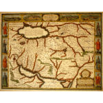
M-12901 - John Speed Map of Persia, c. 1626; âTHE KINGDOME OF PERSIA with the cheef Citties and Habites describedâ London: John Speed, c. 1626 from the Atlas "A PR..
Offered by: Charles Edwin Puckett
View more details |
|
|
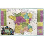
M-12639 - Large separately issued map of France by Hermann Moll c. 1715; M-12639: (Image: 38 1/4 x 24'') ''A New and Exact Map of FRANCE Divided into All its Provinces and Acquisitions...'' London: ..
Offered by: Charles Edwin Puckett
View more details |
|
|
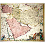
M-12633 - Perrsia, Armenia, Turkey & Arabia in the 1730's; M-12633: (Image: 18 7/8 x 22 1/4'') ''NOVA PERSIAE ARMENIAE NATOLIAE et ARABIAE...'' Frederick De Witt. Amsterdam: Re..
Offered by: Charles Edwin Puckett
View more details |
|
|
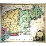
M-12215 - Map of New England and New York, c. 1724; M-12215: (Image: 19 x 22 3/8'') ''NOVA ANGLIA Septentrionali Americae implantata Anglorumque coloniis florentissima'' Nurembe..
Offered by: Charles Edwin Puckett
View more details |
|
|
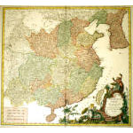
M-11566 - Map of China and Korea by de Vaugondy, c. 1751; M-11566: (Image : 19 x 20 1/2'') ''L-EMPIRE DE LA CHINE...'' Paris: S. Robert De Vaugondy, c. 1751. Beautifully en..
Offered by: Charles Edwin Puckett
View more details |
|
|
M-10821 - North America - French and Indian War Era; M-10821: (Image : 19 3/4 x 19'') ''CARTE GENERALE DE L'AMERIQUE SEPTENTRIONALE'' Paris : Crepy Family, c. 175..
Offered by: Charles Edwin Puckett
View more details |
|
|
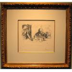
La Coupe et Ie Compotier (The Goblet and the Fruit Dish) by Pierre Bonnard (1867-1947); Lithograph - Bouvet 93, 3rd state of 3. A beautiful proof of the definitive state on thick beige vélin paper, with full margi..
Offered by: Fletcher/Copenhaver Fine Art
View more details |
|
|
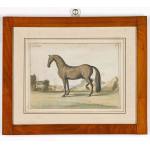
A Set of Four Handcoloured Prints of Horses from "L'art de monter a cheval: ou Description du manége moderne, dans sa perfection" by Baron D'Eisenberg, Published in 1747.; A Set of Four Handcoloured Prints of Horses from "L'art de monter a cheval: ou Description du manége moderne, dans sa perfect..
Offered by: Earle Vandekar of Knightsbridge Inc.
View more details |
|
|
V-1572: Summer in the Country ; V-1572: (Image: 17 3/4 x 25 1/4'') Very detailed original stone-lithograph with exceptionally strong original hand-coloring.&..
Offered by: Charles Edwin Puckett
View more details |
|
|
An Early Map by Johann Michael Seligmann of South Eastern North America including Florida and The Carolina's, Dated 1755. ; An Early Map after Mark Catesby by Johann Michael Seligmann of South Eastern North America including Florida and The Carolina..
Offered by: Earle Vandekar of Knightsbridge Inc.
View more details |
|
|
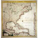
M-10818: Map of North America prior to the French & Indian War; M-10818: (Image : 19 x 23'') ''AMERIQUE SEPTENTRIONALE...1750'' Paris: S. Robert De Vaugondy, c. 1750. Engraved ma..
Offered by: Charles Edwin Puckett
View more details |